MGS MAG/ER Map Interface
Planetary Plasma Interactions Node, Planetary Data System
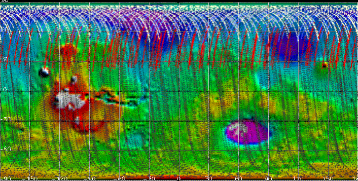
The map displayed below is a tool for finding and displaying the premapping MAG/ER data files containing data taken while the MGS spacecraft was below 200 km altitude.
To find data: Click on the region where you want to find data. You will get a more detailed map of the 30 degree x 30 degree region where you clicked. Then click on that 30 degree x 30 degree map to bring up a table of files containing data in the 5 degree x 5 degree region where you clicked. This table contains links to data files on this DVD, and information about where to find data files that are not on this DVD. To find out in advance whether there are data on this DVD for a map square, hover over the square with your cursor. For more detailed instructions, look below the map.
Key to color coding on the map: The colored curves superimposed on this map represent MGS ground tracks for times when the spacecraft was below 200 km altitude. On this map (but not on other maps in this interface), the ground tracks are color coded according to mission subphase, as follows:
Red = AB-1
Blue = SPO-1
White = SPO-2
Gray = AB-2/Transition to Mapping
DETAILED INSTRUCTIONS FOR USE OF THE MAP:
This map is a tool for finding and displaying the premapping MAG/ER data files containing data below 200 km
altitude. To use the map, follow these steps:
- Click on the map area where you want to find data. Another map will appear that shows a more detailed image of your chosen region. This more detailed map shows a 30 degree by 30 degree region of the Martian surface.
- Click on a spot on this 30 degree by 30 degree map. You will get a table of all the data files for the 5 degree by 5 degree region where you clicked. The PDS label files for the data files also are in this table. The table also tells you which logical volume (CD-sized directory on the DVD) the file is in. This table lists all files for the region, even those which are not on this DVD, but only the files present on this DVD have links. The table lists both MAG and ER data; if there are MAG data but no ER data on this DVD for a given day, then the ER data file names for that day will not have links.
(To find out ahead of time whether there are data on the DVD for a 5 degree by 5 degree square, hover over that square on the 30 degree by 30 degree map with your mouse cursor. If there are no data for the square, a legend will appear.)
- To view a file that is on this DVD (has a link), click the link for that file.
- To find a file that is not on this DVD, use the table to look up the logical volume for that file.
If the logical volume is in the range MGSM_1001 - MGSM_1007, then the file is on the DVD volume DMGSM_1001.
If the logical volume is in the range MGSM_1008 - MGSM_1014, then the file is on the DVD volume DMGSM_1002.
If the logical volume is in the range MGSM_1015 - MGSM_1017, then the file is on the DVD volume DMGSM_1003.
(For files not on this DVD, some file names are in square brackets. A few of these "bracketed" files may not be present on the other DVDs, but the same day of data may be represented there by another, non-bracketed data file.)
For further information and image credits: See the file EXTRINFO.TXT.
Return to top of file